Zeta Roars Ashore Near New Orleans Threatening Worst Hurricane Since Katrina
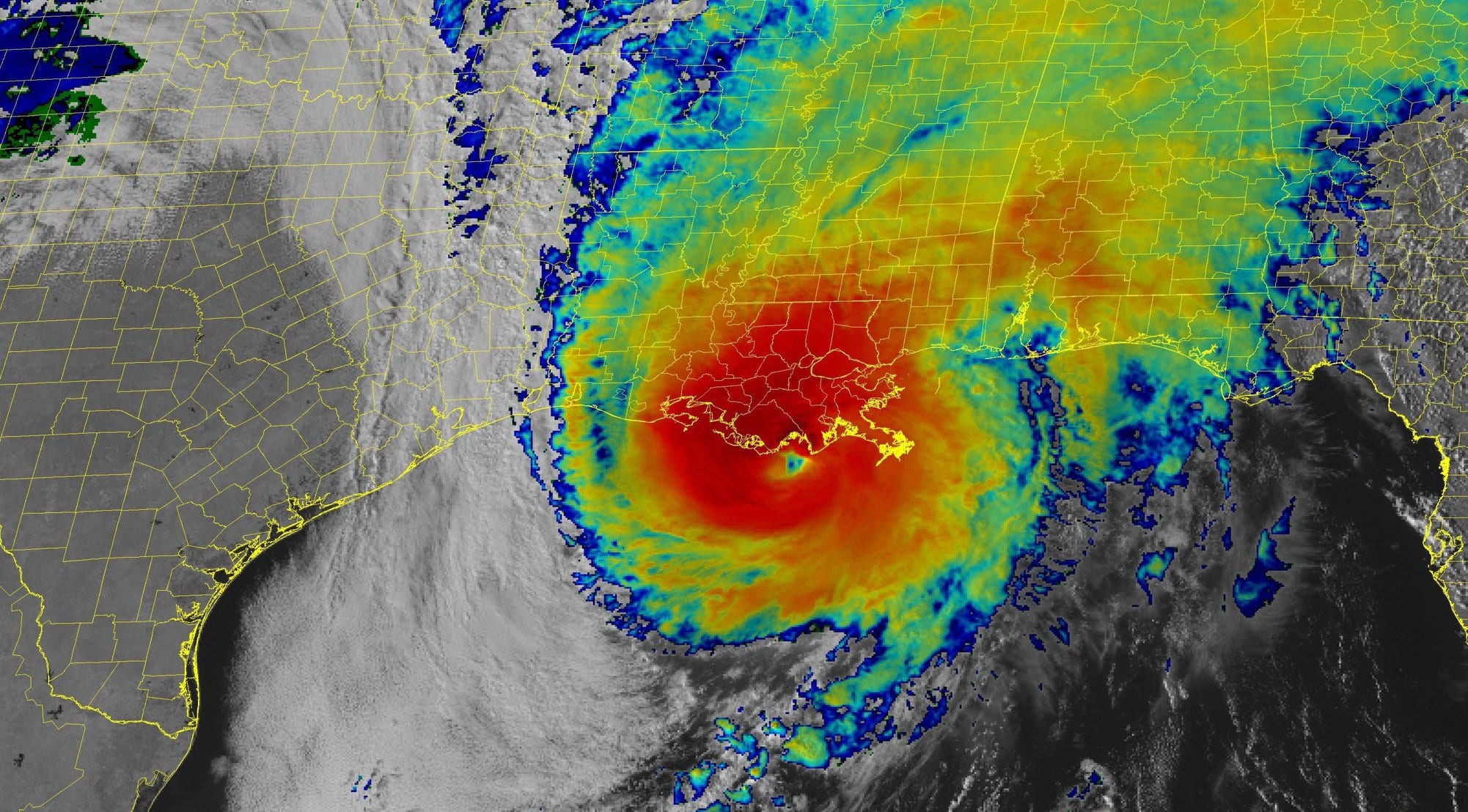
Zeta is making landfall near Cocodrie, Louisiana, with winds of 110 miles (175 kilometers) per hour, becoming the fifth hurricane or tropical storm to hit the state this year, the National Hurricane Center said at about 4 p.m. local time. Never before have so many major storms smashed into Louisiana or the contiguous U.S. in a single season, said Phil Klotzbach, a hurricane researcher with Colorado State University.
While Zeta isn’t as powerful as Katrina, it will run directly over the Crescent City, bringing the harshest winds in 15 years. Yet the storm, moving at a brisk 24 mph, could pass over quickly enough to spare New Orleans catastrophic flooding. Damages could be as high as $5 billion.
At 110 mph, Zeta is just shy of being a major Category 3 hurricane.
“This is going to be one of the worst hurricanes to hit New Orleans proper since Katrina,” Rouiller said.
Zeta is the latest in a grim parade of natural disasters to hit the U.S. in recent months as climate change makes weather increasingly extreme. In California, heat waves, drought and violent winds have combined to fuel a rash of wildfires that have burned a record 4.1 acres this year. And along the East and Gulf coasts, a record 11 named storms have hit the U.S., with five battering Louisiana.
In all, 27 storms have formed across the Atlantic in 2020. So many systems have formed this season that the National Hurricane Center has used up all its official titles and has resorted to the Greek alphabet to designate new ones.
Zeta becomes only one of six storms to hit the U.S. this late in October and the first hurricane to do so since 1985, said Jeff Masters, a meteorologist with Yale Climate Connection. While Sandy was a powerful storm when it came ashore in New Jersey in 2012, it had lost its hurricane characteristics when it struck land.
Zeta grew in strength as it moved across the Gulf, and all told this year six storms have rapidly intensified, short of a record, but indicative of climate change.
“There have been a lot of rapidly intensifying storms and that is something we expect to see in a warming climate,” Masters said.
Zeta may cause as much as $5 billion in damages and losses, said Chuck Watson, a damage modeler at Enki Research, who raised his estimate from an initial $1 billion as the forecast worsened. The storm’s stronger winds bring more dynamic pressure on everything it hits, and there are simply more targets in the way the closer to New Orleans it gets.
While the intensity and number of storms has surpassed the 12 that usually form in an average season, there is no indication things will stop as October ends and November begins.
A potential storm could form in the Caribbean Sea within the next week, which would be called Eta. This would be the 28th storm and tie a record with 2005 for the most in a single year.
There might even be more. A global weather pattern called the Madden Julian Oscillation that’s about to exert its influence on the Atlantic may spark a spate of storms. The Atlantic is still warm enough to spin up hurricanes and there are still plenty of tropical waves, the building blocks of hurricanes, emanating from Africa, Masters said.
In addition, autumn cold fronts moving off North America often swirl into tropical storms.
“I suspect we will see one or two of those this year,” Masters said. “Thirty storms are possible.”
© 2020 Bloomberg L.P.
gCaptain